
The new Location Factors map allows you to evaluate the location of a property and better understand the attractiveness of its location. It enables a quick and efficient location analysis based on various location factors and helps you to identify new micro-locations. In addition, it can be used to review your own property portfolio in terms of location quality and accessibility, to take into account the infrastructural facilities in the vicinity of residential or work locations for the planning of new projects or neighbourhoods, or to close supply gaps.

What exactly does our location factors map provide?
Spatial visualisation
The Location Factors map displays relevant information about the spatial environment within specific geographical coordinates. It is based on the free, user-generated and collaboratively collected geodata of OpenStreetMap provided by Mapbox©. This provides you with a reliable basis for your location analyses.Extensive location factors organised in categories
The environment information is divided into different categories and describes the quality of the location of a property or an address. The categories include all facilities for daily, regular and non-regular needs, important social infrastructure facilities, health, education, work, leisure, sports & local recreation as well as mobility. They are grouped into accessibility areas and their travel times based on the available data.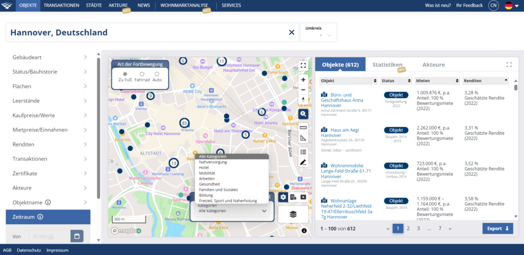
Local amenities
- Restaurants
- Cafés
- Supermarkets
- Drugstores
- Kiosks/Newsstands
- Bakeries
- Banks/ATMs
- Post Offices
- Hairdressers
- Dry cleaners
Mobility
- Stops (bus, train)
- Scooter Sharing
- Bike Sharing
- Car Sharing
- E-charging points
Working
- Coworking Spaces
- Conference/Congress Centres
- Meeting and event rooms
Health
- General practitioners
- Specialists
- Clinics/Hospitals
- Pharmacies
- Medical supply stores
Families & Social Services
- Kindergarten/ Childcare centres/ After-school care
- Playgrounds
- Nursing/Care services
- Other social and health services
- Community centres
- Public drinking fountains
- Public toilets
Education
- Primary schools
- Secondary schools
- Universities/Colleges
- Public libraries
- Adult education centres
- Language schools/tutoring centres
Leisure, sports & recreation
- Theatres, operas, museums, cinemas
- Religious communities
- Sports clubs/halls
- Fitness centres
- Parks
- Small parks
- Swimming pools/ bathing lakes
- Local recreation areas
Targeted location analyses
Use the map to carry out site-specific analyses in order to- identify new micro-locations.
- examine your own real estate portfolio in terms of location quality and accessibility.
- consider infrastructural features when planning new projects or neighbourhoods.
- identify and close supply gaps.
Hotel
Reachability analysis made easy with isochrones
Would you like to accurately determine the accessibility of a selected location or geo-point on the map? Then isochrone maps are exactly what you need! These useful maps allow you to display areas within certain travel times as contours of polygons.
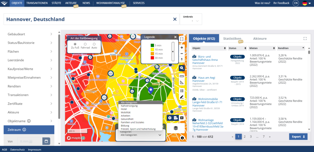
Reachability intervals based on the 15-minute city
Isochrones take into account the fact that not all areas are equally reachable in every direction. This depends on various factors beyond simple distance (as the crow flies). These include the topography of the urban area, traffic conditions and the routes available for each mode of transport (e.g. railway lines, cycle paths, footbridges). The classification of the reachability intervals is based on the urban planning model of the 15-minute city. It requires that all important facilities for daily needs can be reached by people living and working in a district on foot or by bicycle within 15 minutes. Analyse reachability using the isochrone maps. Choose between time (in walking or driving minutes) as well as the desired mode of transport (walking, cycling or car/bus). The new map is a valuable tool for location analysis, urban planning and transport planning. It provides you with detailed insights into the reachability of locations and helps in the development of cities that are both worth living in and are sustainable.